Mirfield Town Trail
Welcome to Mirfield. Why not take a virtual tour around our beautiful village or better still, take the walk yourself.
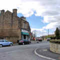
Let's take a glance into our history with the help of buildings and tell-tale signs that have survived untouched for a good number of years. Stand on Eastthorpe Grove in front of Eastthorpe Lodge (now the Library) and look towards the Black Bull, a coaching Inn, pre-1755. To the right of this inn is Ramsden's Butchers, built as a single-storey building in the early 1900s and still with the same family today.
Set off towards Dewsbury on Eastthorpe Lane (Huddersfeld Road) built as the Dewsbury and Elland Trust Turnpike around 1763. On the right-hand side of the road is Trinity Chapel built around 1880 from donations given by local people, one of considerable value from Mr Marmadude Fox of Marma Villa (the Marmaville, Church Lane). Next door to the Chapel over Chapel Lane is the Union Bank (Barclays Bank).
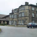
On the left-hand side of the road at the bottom of Knowl Road is Mirfield Town Hall of about 1868 (now the home of the Salvation Army). To the left of the Fire Station is Water Hall, a pre-1624 building. A stroll on the right will take you past Eastthorpe House before reaching Mapplewell Cottage at the bottom of Briar Lane (Parker Lane) a 1752 dwelling. From here to Church Lane was Blake Hall Park, the site of Blake Hall, first built in 1560, re-built in 1745 and demolished in the 1950s. It was home to Anne Bronte in 1839, as governess to the Ingham children, and it may have been where John Wesley stayed on his several visits to Mirfield in the mid to late 1700s.
The hall had two gatehouse lodges, West lodge, opposite Mapplewell Cottage, and East Lodge, opposite Marma Villa. Turn left up Church Lane, with East Lodge on the left and Marma Villa (the Marmaville) on the right, and look at the stone walls on the corner where the remains of a railway bridge stand from the old Bradford branch line, 1848. Two lodges stood each side of the Marma Villa, at the top gate and bottom gate. Blake Hall Park stretched up the left hand side of Church Lane to Pinfold Lane. At the top of Pinfold Lane is St Mary's Church.
There have been four places of worship on this land. Pre-1261, a chapel stood within the boundaries of Castle Hall, firstly of wood (10th Century), and later of stone. The remains of the first Church (1261) are still standing. The second Church was built in 1825 and was the building in which the Bronte sisters worshipped. The present Church was built in 1871. To the left of the Church is Castle Hall Hill, the remains of a motte and bailey with Norman and Danish connections, and the possible site of a primitive fortification of Roman connection. The present Church was built on the site of Castle Hall, first built before the Norman Conquest, which in its later life was an inn, the Beaumont Arms.
In front of the Church are stocks and across the road in Vicarage Meadows is the site of the village pond, where a ducking stool was used in the 1600s. A few yards along Pinfold Lane is the Old Rectory circa 1300, and behind it is the site of the Tithe Barn. Continuing along Pinfold Lane, the path crosses the site of the old Spen Railway Line that ran from Battyeford to Northorpe on its way to Leeds, built by the London and North Western Railway (Northorpe had two railway stations).
At the end of Pinfold, on Crowlees Road, is Ivy Lodge (1700s), the old Vicarage of St Mary's. Turn left into Dunbottle Lane, then right into Flash Lane and continue to the junction of Hepworth Lane and Shillbank Lane. On the right-hand side is the site of the old Paper Hall (pre-1530s) where the last prioress of Kirklees Priory spent her final days after the dissolution of the Priory. Opposite the site of the Paper Hall is a track up to Balderstone Hall (1600s). The track crosses Crossley Lane and onto Northorpe Lane alongside Northorpe Hall (1570s). Turn right down Northorpe Lane and right back into Shillbank Lane up into Hepworth Lane. At the top of Hepworth Lane, turn right into Wellhouse Lane, where on the left-hand side is Wellhouse built about 1576, and to the right of this building is Wellhouse Moravian Church stretching back to Greenside Road. This Church had a school in 1751, attended by James Montgomery (hymn writer) in 1787, Prime Minister Ashquith in 1859, and visited by Anne Bronte.
 Take the footpath from Wellhouse into Greenside Road along the site of Gilder Hall and turn left past the
site of the Pump House on the left and turn right into Folly Road (Lee Green). On the left is the site of
Over Hall. Turn left into West Royd Avenue and at the end of this, on the right is the site of Mirfield's
first school circa 1637, and denoted by the foundation stone, now standing on the site. Cross Knowl Road
into the Knowl and into Nab Lane. At the end of Nab Lane, right onto the Elland Trust Turnpike (Stocksbank
Road) is the House of the Resurrection (1892) and to the right of it is Christ Church built in 1840 but
burnt down in the early 1970's and replaced with the present building of Christ The King.
Take the footpath from Wellhouse into Greenside Road along the site of Gilder Hall and turn left past the
site of the Pump House on the left and turn right into Folly Road (Lee Green). On the left is the site of
Over Hall. Turn left into West Royd Avenue and at the end of this, on the right is the site of Mirfield's
first school circa 1637, and denoted by the foundation stone, now standing on the site. Cross Knowl Road
into the Knowl and into Nab Lane. At the end of Nab Lane, right onto the Elland Trust Turnpike (Stocksbank
Road) is the House of the Resurrection (1892) and to the right of it is Christ Church built in 1840 but
burnt down in the early 1970's and replaced with the present building of Christ The King.
On the right hand side of the road is Bracken Hill, above which is Mirfield Moor. The moor at this end was the land of Fieldhead (now a residential home) and the Waren House. Fieldhead was the home of Dr John Kitson in the early 1800s (Kitson Hill). The first Waren House was built circa 1600 and rebuilt in the late 1800s. An area of common land above the Warren House known as Angram had an area called The Butts, used in ancient times for archery practice. Backtrack up Stocksbank Road to Fieldhead and turn left into Kitson Hill and at moor top on the left, take the footpath across the moor and Warren hill onto the Birstall and Huddersfield Trust Turnpike Road (Leeds Road).
 Cross the road into Far Common Road, where on the left is Roe Head (Holy Bank School),
first built in 1666 and re-built in 1740.Roe Head was school for the Bronte sisters in the 1830s; 1831 for
Charlotte, 1835 for Emily and Anne. Charlotte also taught here in 1835. Backtrack to the Leeds Road and head
down the hill. On the right is Mock Hall (1731) and carry on down to the Three Nuns, built pre 1500 and
probably so named in 1539 when three nuns from Kirklees Priory took over what was then the tavern.
Cross the road into Far Common Road, where on the left is Roe Head (Holy Bank School),
first built in 1666 and re-built in 1740.Roe Head was school for the Bronte sisters in the 1830s; 1831 for
Charlotte, 1835 for Emily and Anne. Charlotte also taught here in 1835. Backtrack to the Leeds Road and head
down the hill. On the right is Mock Hall (1731) and carry on down to the Three Nuns, built pre 1500 and
probably so named in 1539 when three nuns from Kirklees Priory took over what was then the tavern.
Next to the Three Nuns on the left is the field where the Luddites gathered in 1812 before their attack on Rawfolds Mill, Cleckheaton. Also in this area is the gatehouse to Kirklees Priory established in the 12th century, and the site of Robin Hood's grave. Follow the road to its junction with Wakefield Road at Cooper Bridge, and on the right is the Dumb Steeple. The present structure dates from the 1700s but the original may have been a Roman route marker.
Backtrack a short distance to the junction of the two Turnpike roads and proceed back towards Mirfield along Huddersfield Road. On the left is the Manor Park estate site of Green House first built in 1585 and re-built in the 1700s, the home of the Rev Atkinson, godfather of Charlotte Bronte, who regularly visited him in the 1830s while at Roe Head. Some distance along the road is Half Penny Bridge at Battyeford, the site of one of the old ferry landings, used as a means to cross the river. Just past the bridge on Huddersfield Road before the PearTree public house, a glance over the wall into the undergrowth will reveal steps from the road down to the ferry moorings.
Above the road, on the left just beyond the junction of Stocksbank Road, is an area called Snakehill, the first of three sites used as mass graves in 1631 when the plague came to Mirfield. Next to Snakehill is Littlemoor, near Doctor Lane, another plague grave. The third site was Eastthorpe Lane. Mirfield Town centre now beckons once again and on the left is Ings Grove Park, residence in the early 1800s of Dr Bradbury (after whom Doctor Lane was named) and the war memorial. Across the road, at the top of Newgate, are the premises where, in the 1920s, Bickers Joiners and Cabinet Makers was founded before moving to Dewsbury.
St Paul's Road is a history lesson in its own right, a good example of 100 years of architecture - Victorian, Edwardian, pre-war, and modern houses, bungalows, semi-detached and detached houses. On the right of Huddersfield Road is St Paul's Girls' school, built in 1874 using stones from the 1825 St Mary's Church (demolished in 1873). Behind the school is St Paul's Church, of 1881. On the left set among an array of shops is Smith's Ironmongers, which has traded under the same name since the 1920s.
Before reaching the Black Bull once again, look above the shop fronts of Mirfield on Huddersfield Road to the first floors, and there is Mirfield of 100 years ago. Little has changed. The Canal bank is a world of its own, away from the road a scene of tranquility. Meet up with friends at Shepley Marina and enjoy a coffee before a stroll. Shepley Bridge, built in 1732, replaced the ferry that used to cross over to the boathouses, and the canal link was cut in 1766 with help of John Smeaton, of Eddistone Lighthouse fame.
Shepley Boatyard is the first of three along the Mirfield canal (Calder and Hebel Navigation), all of which are back in good business after a lull of several years. Continuing along the towpath towards Mirfield the first bridge carries a track from Huddersfield Road over to the chemical works and the second (now demolished) was the railway bridge on its way to Northorpe Lower Station. On the right is the remains of Canal Lodge. The next bridge is Gill, or sometimes called Hirst where Hurst Lane crosses the canal.
Next comes Bull Bridge at Station Road, believed to be close to an area where bull baiting used to take place. Just before the bridge on the right hand side is a building that comes right down to the water's edge with a door at water level - this used to be the Jolly Sailor and stories are rife of smugglers from the East coast off-loading spirits into the pub cellar.
Under Bull bridge and on the right is the site of the last working malt-house in Mirfield. In 1800, 16 such sites were working in Mirfield. On the left is the Navigation Tavern and Ledgard Bridge boatyard, behind here is the railway station, first opened in 1865. The next bridge is Clifford bridge or Newgate. Leave the canal here and cross the bridge onto Ledgard Bridge (Mirfield Bridge). This crosses the River Calder to Hopton. The first bridge to cross here was a wooden structure in 1303, washed away by floods, as were a number of future bridges on more than one occasion. Floods along the Calder were a regular occurrence.
Turn right over the bridge and proceed into Woodend Road back towards the river. On the right is Butt End Mills and the remains of the Mill Race that gave power to the mills. Woodend Road leads to the site of the old Battyeford Railway Shed and the viaduct that took the L and NWR railway line across the Calder on its way to Northorpe Upper Station. Just beyond the site of the engine shed is believed to be the only surviving Malt Kiln left in Mirfield now derelict but still a wonderful building.
Ahead of this spot the way was blocked for many years although a path is shown on all maps along the river to Battyeford Lock and Boatyard. Following much lobbying and hard work by our local councillors this path has now been restored and has opened up the missing link from Shepley Bridge to Cooper Bridge.
The Mirfield Town Trail has been prepared by Mirfield Civic Society.